
Page 27 -
P. 27
ื
ิ
ิ
โครงการหนังสออเล็กทรอนกสด้านการเกษตร เฉลมพระเกียรตพระบาทสมเด็จพระเจ้าอยู่หัว
์
ิ
ิ
International Seminar on Biodiversity and Sustainable Development in the Mekong River Basin 16
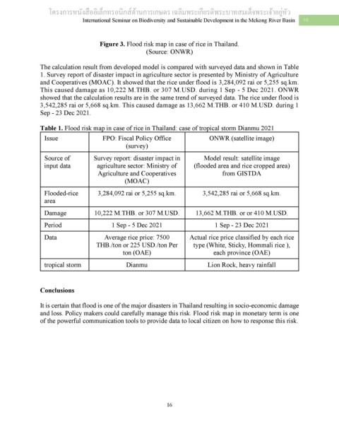
Figure 3. Flood risk map in case of rice in Thailand.
(Source: ONWR)
The calculation result from developed model is compared with surveyed data and shown in Table
1. Survey report of disaster impact in agriculture sector is presented by Ministry of Agriculture
and Cooperatives (MOAC). It showed that the rice under flood is 3,284,092 rai or 5,255 sq.km.
This caused damage as 10,222 M.THB. or 307 M.USD. during 1 Sep - 5 Dec 2021. ONWR
showed that the calculation results are in the same trend of surveyed data. The rice under flood is
3,542,285 rai or 5,668 sq.km. This caused damage as 13,662 M.THB. or 410 M.USD. during 1
Sep - 23 Dec 2021.
Table 1. Flood risk map in case of rice in Thailand: case of tropical storm Dianmu 2021
Issue FPO: Fiscal Policy Office ONWR (satellite image)
(survey)
Source of Survey report: disaster impact in Model result: satellite image
input data agriculture sector: Ministry of (flooded area and rice cropped area)
Agriculture and Cooperatives from GISTDA
(MOAC)
Flooded-rice 3,284,092 rai or 5,255 sq.km. 3,542,285 rai or 5,668 sq.km.
area
Damage 10,222 M.THB. or 307 M.USD. 13,662 M.THB. or or 410 M.USD.
Period 1 Sep - 5 Dec 2021 1 Sep - 23 Dec 2021
Data Average rice price: 7500 Actual rice price classified by each rice
THB./ton or 225 USD./ton Per type (White, Sticky, Hommali rice ),
ton (OAE) each province (OAE)
tropical storm Dianmu Lion Rock, heavy rainfall
Conclusions
It is certain that flood is one of the major disasters in Thailand resulting in socio-economic damage
and loss. Policy makers could carefully manage this risk. Flood risk map in monetary term is one
of the powerful communication tools to provide data to local citizen on how to response this risk.
16